Cat 5 Hurricane Melissa hits 180 mph winds hours before Jamaica landfall
Published in News & Features
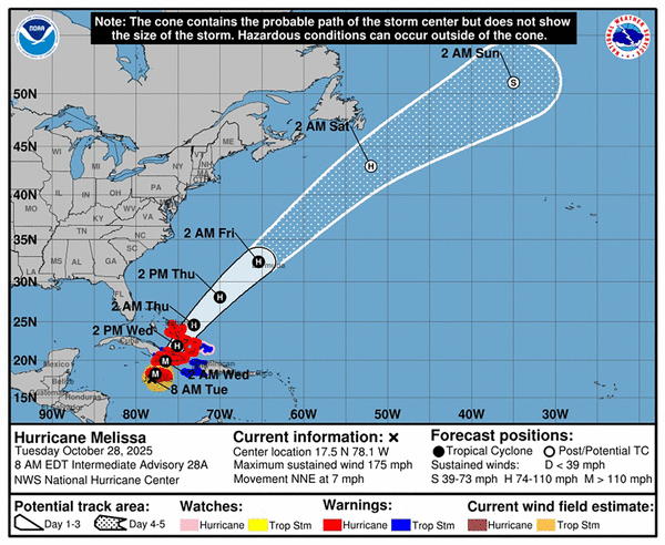
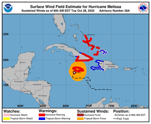
Hurricane Melissa remained a fearsome Category 5 storm with 175 mph winds early Tuesday morning, just hours ahead of what will be a catastrophic landfall in Jamaica.
The National Hurricane Center pleaded with Jamaicans to “remain sheltered!” as the already-deadly storm churned just offshore. One measure of Melissa’s frightening potential for destruction: It already ranked as the 6th strongest Atlantic hurricane on record, beating out Katrina.
As of 9 a.m. Tuesday, it strengthened even more — to 180 mph sustained winds — and was creeping north-northeast at 7 mph, a slight uptick from earlier. It was about 50 miles south-southeast of Negril, Jamaica.
Melissa is set to bring building-collapsing winds, up to 30 inches of rain and between 9 and 13 feet of storm surge on Tuesday as it grinds over Jamaica. Flash floods, mud slides and widespread power outages are all likely.
While official landfall might not occur for a few more hours, it appears Melissa’s eye will cross Jamaica on the western side, potentially sparing the capital Kingston the worst of the wind impacts. However, Delano Seiveright, a member of Jamaica’s Parliament for St. Andrew North Central, told the Herald the situation remains grave.
“A Category 4 or 5 system is catastrophic under any circumstance, and despite the extensive national preparations and many well constructed buildings, no one can ever be truly ready for a storm at that intensity. Should the storm maintain its strength and trajectory, some communities, particularly in western Jamaica, could face damage reminiscent of Gilbert or worse,” he said, referring to the 1988 storm that left 49 dead and destroyed more than 100,000 homes.
Then, it’s coming for Cuba.
Forecasters said the eastern end of the island should start to feel tropical storm effects Tuesday afternoon and hurricane conditions starting Tuesday evening. Melissa is expected to strike Cuba as a powerful Category 4 storm, making landfall early Wednesday morning and bringing up to 25 inches of rain in some spots, as well as 7 to 11 feet of storm surge.
That’s a hard hit for a nation already dealing with power grid failure, outbreaks of mosquito bourne illness and repeated blows from nearly annual hurricanes. More than 880,000 people are being evacuated, officials said.
Next up is a third landfall in the Bahamas on Wednesday afternoon, still as a hurricane.
The central and southeast Bahamas could see flash flooding from up to 10 inches of rain, as well as 4 to 6 feet of storm surge above normally dry land.
©2025 Miami Herald. Visit at miamiherald.com. Distributed by Tribune Content Agency, LLC.


Comments